Kaho Village, Lohit Valley — Riding to India's Eastern End
Last updated: — Route information verified on the ground.
TL;DR
Kaho village on the Lohit River is the easternmost civilian settlement in India, 8 km from the Myanmar border. Getting there by motorcycle requires an Inner Line Permit for Arunachal Pradesh, a separate Protected Area Permit for the Kibithu-Kaho frontier zone, military clearance processed through the local army unit, 340 km (211 miles) of frontier road from Dibrugarh, and a realistic plan for what happens when the road washes out — because it will, somewhere.
There is a specific feeling that happens when you are riding a road and you realise that the road does not continue. Not that it ends at a T-junction or a town or a better road — that it ends because there is nothing beyond it that India administers. The road to Kaho is that road.
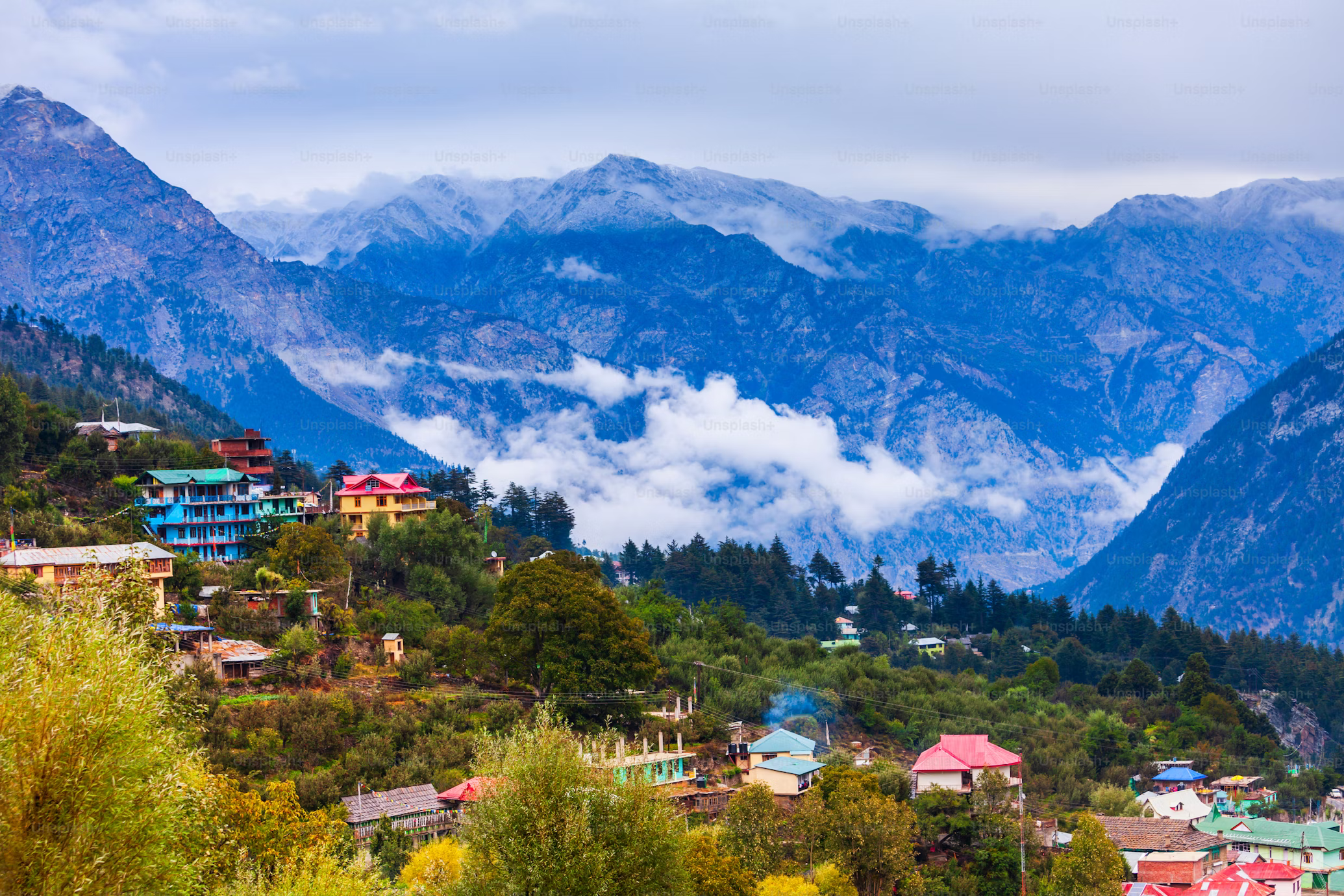
Kaho village sits at the confluence of the Lohit River and a smaller stream, at an elevation of 1,352 ft (412 m), on the eastern edge of Arunachal Pradesh. The Myanmar border is 8 km east. The road from Kibithoo — the last military settlement before Kaho — is 7 km of army-maintained track that the civilian motorcycle uses with permission and care.
We have ridden this route twice. The first time in October 2022, when the road between Hayuliang and Walong was partially collapsed from August monsoon damage and we spent 40 minutes moving rocks to get the bike through a section that the army truck ahead of us had simply driven over and not looked back. The second time in November 2023, when the road was better but the Lohit was still carrying brown monsoon sediment even three months after the rains stopped.
What the Lohit Valley Road Actually Is
The Lohit Valley road north from Tezu follows the Lohit River upstream toward the Chinese border. The Lohit is one of the major Himalayan rivers — it originates as the Zayul Chu in Tibet and enters India through a gorge in eastern Arunachal before widening and slowing through the plains of Assam. On the upper stretch, between Hayuliang and Walong, the river runs in a steep-sided valley and the road runs alongside it, sometimes on a ledge 200 ft (60 m) above the water and sometimes at river level where the valley floor briefly widens.
The distance from Dibrugarh in Assam — the logical starting point, with the nearest airport that has regular connections — to Kaho is approximately 340 km (211 miles). On paper that is a long day's ride. On the Lohit Valley road, it is two days minimum and three days if you stop for anything, which you should, because the stops are the reason to be there.
The road is surfaced between Namsai and Tezu, and then between Tezu and Hayuliang it alternates between tarmac and broken tarmac and sections where the tarmac simply gave up and the army has laid gravel compacted by truck wheels into something that functions as a road surface until the next monsoon. North of Hayuliang the road is whatever the Border Roads Organisation has managed to maintain since the previous inspection, which on some sections is excellent and on some sections is actively alarming.
The valley narrows significantly north of Hayuliang. If you have ridden the Going-to-the-Sun Road in Glacier National Park, you understand the basic geometry — a two-lane road cut into a cliff face above a river with no margin for error. Remove the guardrails, add about 4,000 km (2,500 miles) of distance from the nearest dealership, and lower the road quality by four grades, and you are close to what the upper Lohit Valley road feels like. The difference is that in Glacier you are looking at forest and glaciated peaks. On the Lohit you are looking at some of the densest subtropical jungle in Asia — the valley walls are so steep and so green that in the morning the light does not reach the river until 9am.
The Permit Process — What It Actually Involves
Arunachal Pradesh requires an Inner Line Permit (ILP) for all non-Arunachal residents of India, and a Protected Area Permit (PAP) for foreign nationals. The Lohit Valley frontier zone — specifically the area north of Walong toward Kibithoo and Kaho — requires an additional clearance that is processed through the Army's 2 Mountain Division and is not available through standard tourism channels.
The sequence:
Step 1 — Inner Line Permit for Arunachal Pradesh
Issued online through the Arunachal Pradesh government portal or at the ILP counters in Guwahati, Dibrugarh, and Itanagar. Cost: ₹100 (approximately $1.20 USD) for a 30-day permit. Processing time if done online: 3 working days. At the counter: same day. Required documents: passport, visa, two passport photos.
Step 2 — Protected Area Permit
Foreign nationals need this in addition to the ILP. Apply through the Foreigners Regional Registration Office (FRRO) or through a registered tour operator — the latter is significantly more reliable. Processing time: 10–21 working days from New Delhi. Cost: no additional fee but requires a registered operator's sponsorship. We handle this for all our Arunachal expeditions as part of the expedition package.
Step 3 — Frontier Zone Clearance for Kibithoo-Kaho
This is the permit that most operators do not apply for, because it is not a civilian permit — it is a military clearance. The process involves submitting a request through the District Collector's office in Tezu, which coordinates with the Army's forward brigade in Walong. Turnaround: 2–4 weeks. The permit is issued with a specific date window — you must be at Walong by that date and out by the end of the window. There is no extension mechanism in the field. If the road closes and you cannot make the window, the army unit at Walong will note it and the clearance lapses.
We have applied for this clearance four times. It was approved three times and denied once — the denial came in September 2021 when the area was under heightened activity near the border and civilian access was suspended without explanation. We turned around at Hayuliang and rode the valley as far as Walong. Walong is worth the ride regardless.
Namsai — The Start of the Frontier Character
Namsai is 72 km (45 miles) east of Dibrugarh across the Assam-Arunachal border and is the first town fully inside Arunachal Pradesh on the Lohit Valley route. The Golden Pagoda — officially the Kongmu Kham — is a Theravada Buddhist temple built in 2010 by the Tai Khampti community, in a style that looks more like Southeast Asia than anything you associate with India. The gilded spires are visible from the road 3 km before you reach the compound. The interior is cooler than the outside air by 6–7°C and the monks are young — the monastery doubles as a school.
The Tai Khampti are a Shan people, the same ethnic group that extends through Myanmar and into Thailand and Yunnan. Their presence in the far east of India is a reminder that the political border at Kaho is relatively recent — the cultural geography here is older and does not align cleanly with the map.
We have eaten at a Tai Khampti household in Namsai twice — rice cooked in bamboo, pork prepared with a specific fermented soybean paste that has a depth of flavour I have not found replicated anywhere else in India, and sticky rice pressed into cakes that keep well for two days of riding. The household is not a restaurant and is not findable through any app — it is the house directly behind the monastery's eastern wall, belonging to a family whose name in English translates approximately as "the family of the elder who grows ginger." We found it because we asked the monk at the gate where he ate.
Tezu and the Last Reliable Fuel
Tezu is the district headquarters of Lohit district and the last town with reliable fuel, a proper mechanic, and phone signal before things thin out considerably. The fuel station on the main road is the one — there is a second one marked on some maps on the northern road out of town that may or may not be operational on any given day. Fill up in Tezu. The next confirmed fuel source is Tezu if you come back. There is army fuel at Walong but it is not available to civilians.
The mechanic in Tezu who knows Royal Enfield mechanics is named Bijoy. His workshop is on the left side of the main road as you exit town heading north, identifiable by two Enfield engines on a shelf outside and a 2019 Himalayan with its front wheel removed in the forecourt. He is not always there — he covers a circuit of villages on certain days. We have found him there on 3 of the 5 times we have passed through Tezu. If he is not there, the government circuit house caretaker knows where he is.
Hayuliang — The Last Town
Hayuliang is 110 km (68 miles) north of Tezu on a road that starts reasonable and gets progressively more selective about motorcycles. The town is a small administrative centre — district sub-office, a basic guesthouse, an army installation visible from the road, and the last mobile signal on the Airtel network. BSNL coverage extends further north in theory; in practice it works intermittently in Walong and not at all above it.
The guesthouse in Hayuliang has 6 rooms, cold water, and a kitchen that operates on approximately 4 hours' notice. If you arrive after dark without having called ahead, there is food but it is whatever the caretaker decides to make, which on one visit was an excellent dal and on another was rice with tinned fish that I ate without complaint because the alternative was not eating. The rooms are clean. The blankets are sufficient for the October-November temperature range. The dogs outside are numerous and vocal from about 11pm.
I spent an evening in Hayuliang talking to a retired army officer who had served at the Walong post in the 1990s and had returned to build a house in the town. He described the 1962 war with China — the Battle of Walong, October-November 1962, where Indian forces held the valley for several weeks before the ceasefire — with the specific combination of precision and feeling that comes from someone who has studied the ground rather than the maps. The memorial at Walong, he said, does not convey what the terrain actually required of the soldiers who were there. He was right. We visited the memorial the following day.
Walong — The War Memorial and the Last Bridge
Walong is 80 km (50 miles) north of Hayuliang in the narrowest section of the upper Lohit Valley. The river is loud here — the valley compresses the water and the sound carries up the walls and into the road. The army camp is the dominant structure in Walong. The civilian population is small — 200 to 300 people depending on the season.
The 1962 war memorial sits on a small promontory above the river. The inscription lists the units that fought in the valley and the dates of engagement. The physical terrain around the memorial — the valley walls rising 3,000 ft (914 m) on both sides, the river running fast below, the road visible as a thin line cut into the cliff — gives context to the memorial that no text could provide. Indian forces held this valley for 33 days against a substantially larger Chinese advance. The ceasefire came before the position was lost. The memorial does not editorialize. It does not need to.
We have eaten at the army mess in Walong twice, on invitation from the unit stationed there — once a hot dinner with an officer who had ridden a Bullet from Pune to Leh the previous summer and had opinions about the Himalayan 450's fuel system that were specific and not entirely complimentary, and once a breakfast before the Kibithoo clearance morning. Army cooking at a forward post is not restaurant food. It is hot, plentiful, and completely welcome after 80 km on the upper valley road.
Kibithoo and the Final 7 km to Kaho
The Kibithoo settlement is 7 km south of Kaho. It has an army post, a small Border Roads Organisation camp, and the checkpoint where the frontier zone clearance is verified. The process at the checkpoint is not complicated — documents out, verified, copied, returned, waved through. It takes 15 minutes on a good day. On a day when the duty officer has questions, it takes longer.
The road from Kibithoo to Kaho is army-maintained and varies in quality. On both visits it was rideable on the Himalayan without drama. It follows the Lohit River on the eastern bank through dense jungle that closes over the track in places and blocks the sky. The sun does not reach this section of road until mid-morning.
Kaho is small. The civilian population is approximately 50 people — Mishmi tribal community, subsistence agriculture, some government employees. There is no tourist accommodation. There is no restaurant. There is a small school and a government primary health centre. The river is visible from the edge of the settlement — the Lohit here is wide and brown from the upstream sediment it carries out of Tibet.
Standing at the eastern edge of Kaho, looking toward the treeline that marks the Myanmar border 8 km away, the feeling is not dramatic. It is quiet in the specific way that the end of a road is quiet. The motorcycle is parked on the only flat surface. There is a child watching from a doorway. A woman is washing something in a basin outside a building. The river makes the only continuous sound.
I have been to the easternmost point of India accessible by motorcycle. It does not feel like an achievement. It feels like a place that exists for its own reasons and that we are passing through, which is the correct relationship to have with it.
Practical Information
| Detail | Information |
|---|---|
| Starting point | Dibrugarh, Assam (nearest airport with regular connections) |
| Total distance to Kaho | ~340 km (211 miles) one way |
| Riding days required | Minimum 3 days up, 3 days return |
| Best season | October to February |
| Avoid | June to September (monsoon road closures) |
| Permits required | ILP (Arunachal Pradesh) + PAP (foreign nationals) + frontier zone military clearance |
| ILP cost | ₹100 (~$1.20 USD) |
| PAP processing time | 10–21 working days — apply before travel |
| Frontier zone clearance | 2–4 weeks — apply through registered operator |
| Last reliable fuel | Tezu (~110 km south of Walong) |
| Last mobile signal | Hayuliang (Airtel); Walong (intermittent BSNL) |
| Mechanic | Bijoy, Tezu — Royal Enfield specialist |
| Accommodation to Walong | Guesthouses in Namsai, Tezu, Hayuliang; army rest house Walong (by arrangement) |
| Accommodation at Kaho | None — army facility only, by invitation |
Where We Stay on the Lohit Valley Route
Namsai: Circuit House or a small guesthouse near the Golden Pagoda. The Tai Khampti community homestay (not bookable online — arranged through local contacts) is significantly better than any guesthouse in town. Two rooms, household meals, the fermented soybean pork dish if you are there in October-November.
Tezu: Government inspection bungalow (requires advance booking through the District Collector's office — we handle this) or the private guesthouse on the main road. Clean, functional, no hot water in October. The food at the inspection bungalow is cooked by a caretaker who has been making the same dal for 15 years and has arrived at a very good version of it.
Hayuliang: The single civilian guesthouse. Six rooms. Book ahead — it fills with government officials traveling the circuit. The caretaker's name is Raju. He is reliably there, unlike Bijoy the mechanic.
Walong: The army rest house when the unit extends an invitation, which happens on roughly half our visits. The civilian guesthouse in the town is basic — adequate for a night, not comfortable for two. If the army rest house is not available, we stay one night and move.
What Can Go Wrong — Honest Account
Road closures: The section between Hayuliang and Walong closes without warning after heavy rain even outside the monsoon months. In October 2022 we cleared a rockslide that had deposited roughly 3 cubic metres of material across the road. It took two of us and 40 minutes with a steel bar from the support vehicle. A solo rider would have had to wait for the army truck that came through 3 hours later.
Permit denial: It happened once. We turned around at Hayuliang. We rode the section south to Namsai again and then crossed into Assam and rode west. There is enough to see in the valley without the frontier clearance. The clearance is what makes Kaho possible, not what makes the valley worth riding.
Fuel: We carry 5 litres of reserve on the support vehicle on the upper valley section. The Himalayan 450 has a 17-litre tank and returns approximately 30 km/litre (51 miles/US gallon) on the valley road under load. From Tezu to Walong and back is 160 km (99 miles) — inside one tank if you fill completely in Tezu, with no reserve to spare.
River crossings: There are two seasonal crossings on the upper valley road that are on the road surface, not bridges. In November they are 15–20 cm (6–8 inches) deep and not an issue. In October they can be 35–40 cm (14–16 inches) and require assessment. We have never turned back at a crossing on this route but we have stood at the bank for 20 minutes watching the water before committing.
FAQ
How long does the Arunachal Pradesh Protected Area Permit take for US citizens?
The PAP for foreign nationals is processed through the Foreigners Regional Registration Office (FRRO) in New Delhi and requires a registered Indian tour operator to sponsor the application. Processing time is 10–21 working days. US, UK, EU, and Australian passport holders are all eligible. The one nationality consistently denied PAP for Arunachal Pradesh frontier zones is Chinese — this is a sensitive border area and the restriction is applied without exception. Apply a minimum of 4 weeks before your intended travel date to account for processing delays. We submit all PAP applications for our guests as part of the expedition booking.
Can I ride to Kaho without a registered operator?
You cannot legally enter the frontier zone beyond Kibithoo without the military clearance, and the military clearance is issued only to parties with a registered operator's endorsement. Individual riders — even Indian nationals — require the same clearance for the Kaho section. The ILP for general Arunachal Pradesh travel is issued individually, but the frontier zone clearance is not. Riders who have tried to enter without the clearance have been turned back at the Kibithoo checkpoint and in some cases have had their permit documentation noted for review.
What is the road surface like from Tezu to Walong?
Tezu to Hayuliang (110 km / 68 miles): Alternating tarmac and broken tarmac, generally rideable at 40–60 kph (25–37 mph). A few sections of active construction where the road is gravel for 2–5 km at a time. Hayuliang to Walong (80 km / 50 miles): The most variable section. Can be good — compacted gravel and patched tarmac at 30–40 kph (18–25 mph). Can be difficult — active landslide debris or monsoon-damaged sections requiring slow, careful navigation. We have never found this section impassable to a loaded Himalayan, but we have ridden it at 20 kph (12 mph) for extended stretches.
Is there any accommodation at Kaho itself?
No civilian accommodation exists at Kaho. The army manages the area and the civilian guesthouse at Walong is the practical overnight point for the Kaho day ride. Riders who want to spend longer at Kaho need army hospitality, which is genuinely offered when it is offered and cannot be arranged in advance with any reliability. We have found that riding the 7 km from Kibithoo to Kaho in the morning, spending 2 hours there, and returning to Walong for the night is the right structure.
Related Reading
- Arunachal Pradesh motorcycle expedition — full route from Dibrugarh to Tawang including Ziro Valley
- Northeast India motorcycle tour — all eight northeastern states
- India motorcycle permit guide for foreign riders — complete permit reference including PAP process
Planning a ride to Arunachal Pradesh? The permit timeline is the variable that determines everything else. We start the paperwork 6 weeks before departure. Tell us your dates and we will tell you if it is achievable.